Wayanad Disaster - July 2024
Wayanad Topography
Wayanad, a district headquarters in Kerala State, India, is a unique geographical phenomenon in the Western Ghats. The Western Ghats stretch about 1600 km and begin from the Satpura range in Gujarat and extend to the Marunthuvazh Malai village in the Kanyakumari district of Tamil Nadu in southern India.
These mountains are spread over six states: Gujarat, Maharashtra, Goa, Karnataka, Tamil Nadu, and Kerala. They cover an area of 1,40,000 square km and expand to 1600 km across these states.
The mountain range is relatively continuous and only discontinued for about 39 km at Palghat Pass.
The Western Ghats are a natural obstruction for the southwest monsoon and, hence, cause heavy rainfall on the west of the Ghats. They host more than 5000 flowering plants, 139 mammals, 500 species of birds, and 325 globally endangered species.
The Western Ghats are considered to be older than the Himalayas.
The Narmada River originates from the northeastern end of Satpura, and Tapti originates from the eastern-central part of Satpura and ends in the Arabian Sea. Godavari and Mahanadi originate in the western ghats and end in the Bay of Bengal.
Anamudi in Kerala is the highest peak at 2695 metres above sea level of the western ghats.
The soils south of the Wayanad district are laterite soils that have morphed due to rains and climate changes. They are brown or reddish brown. There is not much organic matter, and there is limited nitrogen, phosphorous, and potash.
Causes of Latest Landslides
There are several reasons for landslides, both natural and human-induced:
· Man-Made:
Due to the latest tourist developments in Wayanad region and with tourism promotion worldwide, people's interest in tourism is increasing rapidly. The Western Ghats are ecologically beautiful, so people are interested in visiting them. Developing tourism requires infrastructure like resorts, buildings for residents, road and rail transport facilities, electricity, and daily necessities.
The Wayanad region has been developed into a tourist attraction with homestays and monsoon tourism. This commercial development has resulted in an irregular increase in construction activity that interferes with the natural surroundings on Wayanad's delicate hills.
With commercial development, the area's population density will increase, ground pollution levels will increase with the use of plastics, and air pollution will increase with motor vehicle usage and tree cutting. These activities, in turn, affect the environment of these delicate hills of Wayanad.
The International Journal of Environmental Research and Public Health 2022 found a 62% reduction in forest area cover from 1950 to 2018. The area under tea plantations has also increased. The development of single crops in large areas leads to loosening topsoil.
· Natural:
The natural and the leading cause is the heavy rainfall of 527 mm in 48 hours starting in the early hours of July 30 on the tender slopes of the hills and the type of soil of the western ghats at Wayanad.
Environmental changes, such as climate warming, have led to cloud bursting, which has caused heavy rainfalls.
The Two-Hour Disaster on July 30, 2024
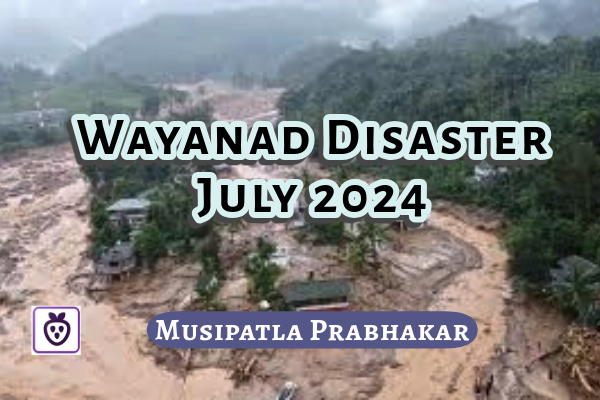
In the early hours of July 30, 2024, at about 2 a.m., the Wayanad district of Kerala was hit by abnormally heavy rain at night. On the same night again, at about 4.10 a.m., another heavy rain fell for the second time. These two downpours resulted in landslides on the uphill slopes, which developed into sweeping, swollen masses of mud, water, and boulders crushing down onto the houses thousands of metres below on the unexpected and helpless residents in the affected areas that night. These two rain havocs and the resulting landslides with boulders left no chance for the people to escape, and the sweeping swollen mud mass took their lives in their sleep.
The swollen mud mass moving over the houses and their sleeping inhabitants merged into the river. With the flood of sweeping mud mass, the river changed its course and flooded the neighbouring areas.
During its flow, the swelled mud mass with boulders swept away over 200 buildings in Mundakkai and Chooralmala villages.
The disaster was heavy. In Chooralmala village, all its houses and shops were buried under mud and boulders. Their two-wheelers and four-wheelers were damaged and thrown hither and thither.
Mundakkai and its neighbouring regions, another worst-affected area, were famous for resorts, trekkers, honeymooners, and nature-loving tourists. It also housed several families. This hill area has large Cardamom and tea estates. People from every family in the village were lost.
The preliminary estimate was that at least 156 lives were lost, affecting tea estate workers and their families who lived in tiny houses.
The continuous heavy rain caused upper-level hill soil and boulders to fall. A heavy downpour on Monday night resulted in the sweeping flow of bouldered mud water on houses and people.
The National Remote Sensing Centre showed images of 86000 square metres of slipped land. The slipped soil and boulders from the top formed a swelling mud mass and swept several km down into the Irpuzhauvazhinji, a tributary of the Chaliyar River. The tributary and the river flooded, and their bunds eroded with the flooded landslide boulder and mud debris.
The debris from the landslide flowed down the stream and into the Chulika River. At the Chulika River near Malappuram, several kilometres down the hill, the landslide flow washed away dead bodies and body parts of people. People lost some of their body parts in the sweeping boulder and mud mass flow and died.
Rescue Operations
The Chief Minister of the Government of Kerala, Sri Pinarayi Vijayan, ordered all government agencies to mobilise for search and rescue operations. The rescuers faced challenges because the bridge and the roads connecting Mundakkai and Chooralmala were washed away in the landslide flow.
Hence, the Army planned to airlift the stranded people with helicopters from Mundakkai. However, they found that landing helicopters was difficult in the landslide areas, so helicopters were not used.
The Army, Defence Security Corps, National Disaster Response Force, Forest Department, Fire and Rescue service personnel, and medical teams were involved in the rescue operations from morning on July 30.
On the next day, July 31, the death toll was 156, with many to be found.
The rescue teams were searching for people trapped in the debris.
Army Constructs Bridge across Irpuzhauvazhinji River
The rescue operations had difficulty with the continuous rainfall and the risk of further landslides. On July 31, the NDRF had to pause rescue operations overnight due to continuous rainfall and possible landslides.
By the evening of August 1, the Army had constructed a temporary bridge across the river with prefabricated steel trusses to reach Mundakkai.
The bridge was of great help to the rescue operations in transporting men and machinery.
The People's Grief
The death count on the morning of August 1 was 167, including 22 children, with 219 injured and 191 missing. The rescue teams admitted the injured to hospitals. The Army and NDRF teams shifted 1592 persons to safe places.
The dead bodies were handed over to the relations after a postmortem and identification.
On the morning of July 30, at about 3 a.m. in Chooralmal, they heard the sound of a mud mass moving when people were asleep. People started shouting and crying and climbed onto the roofs. There was no power. The downpour was heavy, and it took away all the people and their houses within half an hour, with mud masses and boulders falling on houses.
The rain swept away all the houses in Mundakkai. Before the rain, there were 500, and after, about 45 houses remained.
One can imagine the intensity of the disaster as it swept a two-storey reinforced concrete building and its residents in Mundakkai. One of the house's residents, Moidu, caught hold of the fan with his daughter and grandchild on his back. But the swollen mud waters reached his neck. Then, he, who had earlier bypass surgery, dared and came out of the house with his daughter and grandchild on his back to a safe place. The landslide swept others in the house with the swollen mud-boulder debris. The relief team admitted him to a relief camp at the Government Higher Secondary School in Meppadi Town.
The landslide took away people in their sleep, and the dead bodies were swept into the river Chaliyar downstream at Munderi. Many bodies in the swollen mud-boulder mass fell through the steep waterfalls of Soochippara, Kanthanpara, and Meenmutty before reaching the river, and hence, many lost their body parts.
There were some bodies of children and elderly trapped in the debris under the fallen houses. The utensils, gas cylinders, books, clothes, cots, beds, etc., were found in the wreckage of the houses.
The survivors were in shock, having lost their children, spouses, parents, and all clothes, books, house and belongings. They were left alone with or without clothes on their body. Everything happened within hours.
Imagine the fate of happy people who enjoyed the day with family, friends and children, had dinner, and slept peacefully to get up to lose family, children, near and dear and their houses, groceries, money, and all the daily necessities the following day. Two early hours of downpour changed their lives drastically and threw them into a dark, unimaginable future life.
But alas, for some, no one thought it was their last day on this Earth. Some got crushed under boulders, some got swept away with swollen mud waters into the river, and limbs got broken; for some, they could not help their children and family members being swept away before their eyes, with all these happenings in front of them, unable to help themselves or family members, within a short period of two hours the survivors went into shock. They lost all that they procured over several years of their life. The survivors are now as if they were just born, not as a child but as adults without the care of a mother and father and no one except the Government. The Government helped them with food, clothing and shelter and is arranging for counsellors to help them recover to normalcy from the shock.
Final Stage of Rescue Operation
The operations reached their final stage on August 4, 2024. About 10,000 people were rescued and sheltered in relief camps. The total death toll was 219, with 203 missing and 143 body parts found. Some were undergoing hospital treatment; others were discharged and sent to rehabilitation centres.
To find out the possibility of more dead bodies in the debris, eleven trained dog squads of Army and police were utilised. These dog squads helped recover 15 bodies from the debris.
Ham Radios transmitted information to and from the people of the devastated area. They were helpful as the mobile towers collapsed.
Identification of the Dead
Identifying the retrieved bodies was challenging, as the body faces disfigured and limbs broken and mutilated. Mass pyres and graveyards were prepared per their religious rites at Meppadi, Chooralmal and other places.
Rehabilitation Measures by the Government of Kerala
Chief Minister of Kerala State, Sri Pinarayi Vijayan, has announced Rs six lakhs as an exgratia payment for the next kin of the deceased in the heavy rain and landslide havoc. The same applies to the kin of the missing persons as per the police records.
He ordered compensation of Rs 75,000/—for 60% disability and Rs 50,000/—for 40% to 60 % disability due to the rain havoc.
The Government offered to provide kitchen utensils and cooking gas free of cost to relocated families and individuals.
The survivors staying in rented accommodation or with their relatives will receive Rs 6,000/—per month towards rent.
The individuals who lost their important documents will get them free of any fee.
Sri Vijayan said the Government will provide houses in the planned modern township.
Prime Minister Sri Modi Ji visited these areas on August 10 and announced help from the Government of India.
IMD's Warnings
The India Meteorological Department's (IMD) press release of July 23 warned of 'hefty rainfall at isolated places in Kerala', suggesting a forecast of heavy rainfall on July 25. It also suggested heavy rain over isolated places in Kerala from July 23-27.
On July 29, IMD issued an orange alert for heavy rainfall at isolated places in Kerala. The first and second landslides occurred on the night of July 29 and early morning of the 30th.
The IMD issued a red alert on July 30 at about 1.10 p.m. and an orange alert for July 31 and August 1.
These assessments of IMD indicate that they require up-to-date technology to predict correct and timely warnings, which enables people to take quick action, particularly in this region.
Government of India's initiatives to protect the Ecology of the Western Ghats
· Gadgil Report on Western Ghats
The Gadgil committee, named "The Western Ghats Ecology Experts Panel (WGEEP)," was formed by the Ministry of Environment, Government of India, in 2010 to protect the Western Ghats. The committee submitted its report in 2011 on the entire Western Ghats, covering 1,29,000 square km. Based on ecological sensitivity, the Ghats are divided into three zones: ESZ-1, ESZ-2, and ESZ-3. It declared 75% of the Western Ghats Eco-Sensitive. The committee suggested restrictions on development in the first and second zones.
The Wayanad region was classified under ESZ-1, which prohibits mining, new roads or railway lines and limits the construction of dams, thermal power projects, and ecotourism. The committee recommended that chemical pesticides and plastic bags be prohibited in ESZ-1 and ESZ-2. It suggested a complete ban on using Genetically Modified Crops in the entire region.
No new construction related to dams, railway projects, major road projects, hill stations, or special economic zones will be created in the ESZ-1 and ESZ-2 areas.
No land should be converted from forest to non-forest usage and public to private ownership.
The public protested against the Gadgil Report, saying it affected the region's livelihood and economic development on the following points.
It was criticised for not suggesting a solution for the revenue loss resulting from its recommendations.
Banning dam construction in this region will negatively affect the power sector, considering the nation's rising energy needs.
Sand miners were highly critical of the recommendations as a blanket ban on new mining was placed.
Farmers of Kerala were highly apprehensive about losing their livelihood.
Hence, the report was not accepted by the concerned State Governments.
· Kasturirangan Committee Report on Western Ghats
This committee submitted its report on April 15, 2013. It was then made public and sent to all stakeholders for comments and responses.
All six related states did not accept the Gadgil Committee report based on these protests. In 2012, the Government appointed a ten-member committee under the chairmanship of former chairman ISRO Kasturirangan to address the issues. The committee was called a High-Level Working Group (HLWG).
This committee's objective was to examine the report of the Gadgil committee in light of the protests of all the region's stakeholders.
This committee submitted its report on April 15, 2013. It was then made public and sent to all stakeholders for comments and responses.
· Recommendations by the Kasturirangan Committee
The Kasturirangan report recommended that only 37% of the Western Ghats should be classified as an Eco-Sensitive Area (ESA).
Around 60% of the Western Ghats' area is categorised as a 'Cultural Landscape' with human settlements, plantations, and agriculture.
The remaining area, around 60,000 square km, should be classified as a 'Natural Landscape,' a biologically diverse area.
The report recommended banning mining, quarrying, thermal power plants, township projects, and other 'red industries' in the Eco-Sensitive Area (ESA).
Kasturirangan's report suggested a cumulative Impact Assessment be done for Hydropower projects.
Process and production techniques in the 'orange category' industries (food processing) are to be planned to reduce environmental damage to a minimum.
Community ownership-based eco-sensitive tourism should be promoted.
Transport-related infrastructure projects are to be approved only after the Cumulative Impact Assessment. Railway infrastructure projects must be carefully planned to minimise their negative environmental impact.
Kasturirangan's report was also not acceptable to the public.
· Criticism Against Kasturirangan Committee Report
Following are the primary criticisms levelled against the Kasturirangan report:
Division of the Western Ghats into different zones was made based on aerial data and remote sensing rather than doing the ground assessment. This led to several errors at the ground level.
The farmers feared eviction if the recommendations were implemented.
The report did not consider some sensitive areas under Eco-Sensitive Area (ESA).
Gadgil and Kasturirangan's reports classified Wayanad as an Eco-Sensitive Area-1.
Government of India Draft
A first draft notification on the Western Ghats was issued in March 2014 and was later reissued during these ten years. The last issue was in July 2022. The sixth draft notification on" Conservation aspects of the disaster-prone pristine ecosystem and the region's rights, privileges, needs and developmental aspirations" was issued on 30th July 2024. It is open for comments from the public for 60 days.
The draft notification proposes declaring 57,000 sq. km of the six states as ecologically sensitive areas, including 9993.7 sq. km of Kerala. This comprises 13 villages affected by the recent rain havoc landslide in Wayanad.
What Next?
Governments must strategize to strike a balance between development and the environment. With the increasing population, people must be educated on the importance of keeping the natural environment safe to benefit present and future generations.
------------------ The End ------------------
Comments (0)
Please login to share your comments.